Technical detail for participants
These pages are specifically aimed at those involved in the detailed technical aspects of OneGeology and the processes required to provide your geological map data to the web. Minimum technical requirements and specifications are outlined and the levels of involvement possible are explained.
For a brief overview of the aims and progress of the initiative, please click here.
The aim: One service — many uses
Geological map data will be made available as a distributed web service, using the OGC 'web feature mapping' approach. The priority of OneGeology is to make available interoperable, Internet-accessible, scientifically-attributed data and to make progress at levels appropriate to participants' capability. Surveys and organisations are encouraged to work together to develop and implement the required interchange standard to make their data interoperable. This can be achieved by using GML (Geography Mark-up Language) based data.
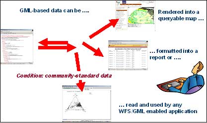
GML based data (including GeoSciML) can be used in many different ways. For example, basic data can be rendered into a map that can be interrogated for further detailed information, the data can be formatted into a report, or it can be used in other applications for further development.
Map specifications
Prerequisites for OneGeology involvement:- the target scale is 1:1 000 000 but the project will be pragmatic and accept a range of scales and the best available data.
- to provide a WMS you only require a georeferenced scanned paper map or raster or vector digital GIS data.
- to provide feature and complex data queries via GeoSciML based WFS you
- need to map from your GIS (ESRI ARCINFO, MapInfo, ORACLE etc.) data store to WFS server configuration (Geoserver or Mapserver/Cocoon).
- need a (trained) person week, but includes getting WFS going with open source software (IT issues).
- should note that the mapping process will be simple (small part of GeoSciML) if the themes chosen by the geological specification group are simple e.g. simple polygons with few attributes such as bedrock, lithology and age.
WMS = web map service — this is level 1, the minimum for OneGeology
WFS = web feature service, this holds more detailed data.
Technical specifications and requirements
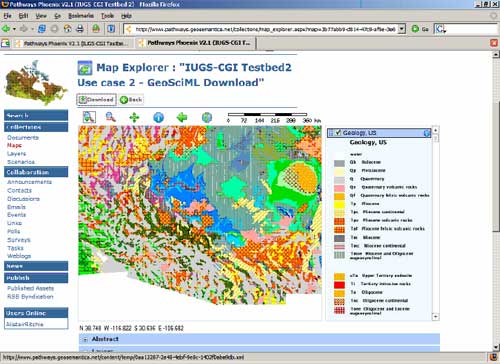
Example of a GeoSciML downloaded map — one of the aims of OneGeology
Level 1 involvement with OneGeology web services
Geological surveys and similar institutions that wish to contribute to the OneGeology initiative at Level 1 are aiming to provide an OGC Web Mapping Service (WMS) from a web server within their organisation, or hosted by a neighbouring organisation, of some basic geological maps.
The maps will appear in the computer users application, which may be a web browser, in a raster or image form. Such image maps will be combinable with other spatial datasets depending on the application the user wishes to apply. If the data that is the source behind the WMS is of digital vector data form with attributes associated with those vectors e.g. information attached to a particular type polygon or boundary then the WMS will allow the display of such attributes for each polygon. If the data source behind the WMS is of a simple scanned raster type e.g. scanned from a paper map and served as a raster image, then such attributes or further informa0tion do not exist for separate polygons.
Cookbooks giving best practice on using open-source, i.e. freely available, software to set up such WMS will be provided by the OneGeology initiative along with guidance on what sort of data to serve and how to represent it.
Level 2 involvement with OneGeology web services
Geological surveys and similar institutions that wish to contribute to the OneGeology initiative at Level 2 are aiming to provide an OGC Web Feature Service (WFS) from a web server within their organisation, or hosted by a neighbouring organisation, of some basic geological 'map' data.
These WFS will allow the user to download data in GeoSciML form resulting from queries (geographic or other attribute based) of the data over the web so that the same query could be sent to some/all of the OneGeology contributors WFS services around the world.
Cookbooks giving best practice on using open-source, i.e. freely available, software to set up such WFS will be provided by the OneGeology initiative along with guidance on how to configure a WFS using GeoSciML from the institutions' internal digital databases.
Cookbooks
What is a cookbook?
A cookbook is a best practice manual 'containing a straightforward set of already tried and tested recipe or instructions for a specific activity'.
A series of 'cookbooks' giving best practice on using open-source, i.e. freely available, software to set up WFS will be provided by the OneGeology initiative along with guidance on how to configure a WFS using GeoSciML from the institutions' internal digital databases.
These documents will provide specific work-flow guidance notes to enable full participation of your organisation regardless of expertise, location or amount of data available.
Cookbook specification
A series of OneGeology-specific branded cookbooks are available as follows:
- Cookbook No 1 explains how to setup a WMS (view) service (with no GML/GeoSciML).
- Cookbook No 7 explains how we map from the backend database to the GeoSciML WFS service.
- Cookbook No 8 describes how to set up a WFS (download) web service on your web server using open-source software.
- Cookbook No 6 describes how to set up a WCS (download) web service on your web server using open-source software.
The Cookbooks are available on the Downloads page.
Cookbook 1 (the WMS cookbook) is now also available as a set of web pages.
Please note the web pages version of this cookbook is to be considered the master copy of the cookbook and not the PDF version available from the downloads page, (which will include a date to show when it was last synchronized with the web version). If you find an inconsistency between the PDF version and the web page version, you should consider the web version to be correct.The aim is that multilingual versions will be available wherever possible.
Support services
Services which will be available to OneGeology participants to help advise and assist with serving data to the Portal include:
- a series of 'cookbooks' for step-by-step guidance.
- a support team, and email helpdesk.
- a series of regional workshops to build technology capability within staff.
Work will be based on open-source technologies so all the OGC web services required software can be purchased cost free. However, a contributing survey must either have its own standard Internet server or have access to such a server through a neighbouring or regional organisation.