Deltas
When a river reaches a lake or the sea the water slows down and loses the power to carry sediment  . The sediment is dropped at the mouth of the river. Some rivers drop so much sediment that waves and tides can't carry it all away. It builds up in layers forming a delta.
Some deltas are so large that people can live on them. The Nile delta is a very important farming area in Egypt.
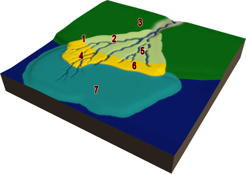
Deltas have a fairly flat section called a delta plain that is above water. The river cuts many small channels through the delta plain. These channels are called distributaries. New sections of delta build up at the mouths of the distributaries.
The rest of the delta is under water  . There is a steeply sloping delta front that faces the lake or ocean. The prodelta is furthest away from the mouth of the river and is deepest under water.

Click to view larger and see the legend.
- Limit of tidal inundation
- Upper deltaic plain
- Alluvial valley
- Active delta
- Abandoned delta
- Lower deltaic plain
- Undersea deltaic plain
Delta sediments are shown as bluish fingers on the geological map  of Indonesia.
Can you find the delta at the eastern edge of the map? Hint: The delta looks like lots of short fat fingers poking out into the ocean.
Delta types
Deltas have different shapes depending on how much sediment is deposited by the river compared to how much sediment is eroded and redeposited by waves and tides.
A river dominated delta, such as the map below of the Mississippi delta, Louisiana, USA, is sometimes called a bird's foot delta because of its shape. Long, narrow mounds of sediment called levees build up along the sides of the narrow distributary channels.
Tide dominated deltas have long and narrow offshore bars or islands at the mouth of the river, such as in Western Papua New Guinea, shown on the map below.
Wave dominated deltas look like a flattened triangle. The lines running across the delta are ridges that formed as the delta built up, shown in Caravelas, Brazil, on the map below.
« Back 


