3.4 The legend for the scanned map
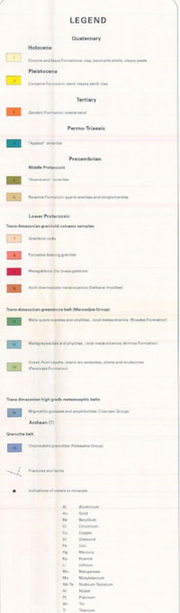
A WMS based on a scanned map will not have the ability to click on a symbolized polygon and see what attributes and therefore what classification it has according to the legend. A WMS based on GIS digital data polygons and attributes does have this capability and the legend is automatically created from such information by the MapServer software. However for this scanned map based WMS it is possible to associate the scanned legend file for the map — which in the case of the Suriname example looked like this — with the WMS service by including the following lines in the Metadata section of the MapServer.map configuration file which is discussed later:
METADATA
...
WMS_STYLE "default"
WMS_STYLE_DEFAULT_LEGENDURL_HEIGHT "353"
WMS_STYLE_DEFAULT_LEGENDURL_WIDTH "253"
WMS_STYLE_DEFAULT_LEGENDURL_HREF "http://www.dinoservices.nl/TNO_Suriname_Geology/surinameLegend.png"
WMS_STYLE_DEFAULT_LEGENDURL_FORMAT "image/png"
...
It is an OneGeology target aim to provide any legends in English as well as the originating language; in this case you would have to create an image file with a relevant translation. Note that the image format should be one that can be directly displayed by a web browser, i.e. JPEG, PNG or GIF. To keep things simple we have decided that any alternative language WMS services should be completely separate language specific services e.g. the BRGM plans to serve an English service and a French one.
Section last modified: 13 July 2011