1.3 What type of data should be served as a contribution to OneGeology Level 1?
As cited in the brief overview of the OneGeology initiative (elsewhere on this web site ~ https://onegeology.org/technical_progress/home.html)
each contributor decides which maps to contribute and it is anticipated that the majority of contributed maps will be bedrock and/or superficial maps, lithological and/or lithostratigraphical and/or chronostratigraphical where possible, but again, each contributor decides.
If chronostratigraphical symbolization is being offered then if possible the target scheme to use would be the IUGS 2009 colour scheme (https://www.seegrid.csiro.au/wiki/pub/CGIModel/GeologicTime/ISChart2009.pdf).
If you wish you are also encouraged to go a step further and follow the GeoSciML-Portrayal schema, which would allow your age service to be queried and re-symbolized using CGI URI codes. See (Section 7) for details on how to enable GeoSciML-Portrayal in your service.
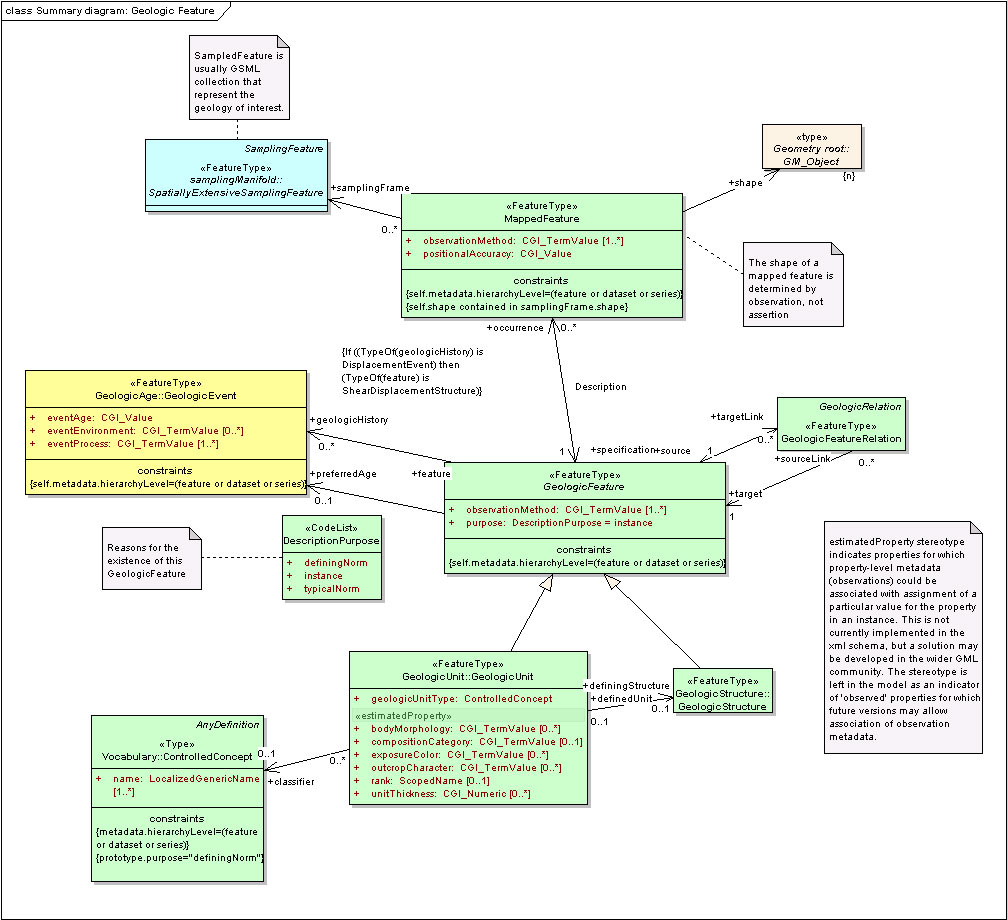
This definition of these target ideal data contents represented by the Level 1 participants was agreed at the Brighton meeting but it also forms a small part of the GeoSciML logical model of geoscience concepts that OneGeology aspires to use to serve Level 2 Web Feature Services (WFS) in which the actual data in GML XML form is served over the web and not just a pictorial image of the map as in a WMS service.
A relevant UML (Universal Modelling Language) fragment of that GeoSciML model is shown below for those who want to understand the long term context:
Any Level 1 participant that plans in the long term to serve a Level 2 OneGeology WFS web service will want to serve this type of category of data to make it straightforward to move from a Level 1 WMS to a Level 2 WFS.
We emphasise that these geoscientific categories or feature types are only the target aim for OneGeology and if you have other data that you wish to serve and contribute then you are very much encouraged to do so. Similarly, whilst the target scale of data to be published is 1:1 000 000 OneGeology will happily accept data between the scales 1:500 000 and 1:5 000 000 with some other useful baseline datasets being of even larger scale. For example the British Geological Survey has decided to contribute its 1:625 000 scale data — and as it would take time and money to change this to a 1:1 000 000 scale it is not worth the effort to make this change.
A WMS is served from digital data and this comes in two forms; vector digital geological data in a GIS format such as ESRI's shapefile or a digitally scanned map in an image format such as GeoTIFF or JPEG. A digitally scanned map in an image format is required if the map you wish to serve is only currently available in paper map form — perhaps from a historical library source.
If you wish to serve a WMS from a paper map source then follow Section 3 (of the WMS cookbook) on scanning a paper map and then proceed to Section 4 and Section 5 on setting up a WMS using your choice of software.
Section last modified: 4 Jan 2016