Board
OneGeology is governed by a Board of representatives made up from Geological Survey Organisations (both national and where appropriate state/provincial/territorial) from each of the seven regions and is supported by the permanent administration provided by the Lead Parties, the British Geological Survey and BRGM. Each of the seven regions may nominate one person to hold office as a Board Member. The process of appointing that Board Member is the responsibility of each region, as is their duration of office, providing that duration is not less than 6 months. The regions may call upon OneGeology administration to recommend and coordinate the appointment process where necessary. In recognition of the substantial logistical and financial support provided to OneGeology, an additional two Board seats (one to each Party) are given to the Lead Parties.
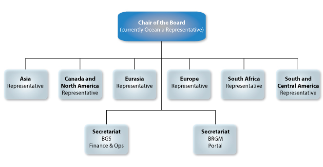
Roles of the Board
- The Board Members will appoint a Chairperson from within their number and agree on the term and protocol.
- The Board develops a terms of reference (ToR) with assistance from the administration. The Board determines their operational and meeting procedures that apply to the office of Chairperson.
- All Board Members, or any other person as authorised by the Board in the ToR, can call a Board meeting (or virtual meeting) at any time, subject to fourteen (14) day notice.
- Each Board Member has one vote at a Board meeting.
- A quorum is a minimum of majority of Board Members, dependent on their number. The Chairperson will hold a casting vote should a simple majority not be reached.
- Each Board Member must accept responsibility to actively promote and participate in OneGeology and its governance and fully and fairly represent the region from which they are drawn.
- The time and expenses of Board Members is to be funded through their parent organisations.
- The Consortium, its Board, and management staff have the responsibility to further the Objectives of OneGeology. The Board and Consortium has the power to do anything within the law that may promote or may help to promote any or all of the Objectives, but nothing outside the Objectives.
- Income from membership fees and other sources is to be used to supplement the administrative services and technical coordination functions supported at a core level by the Lead Parties. The Board may choose to employ staff as are necessary for carrying out the work of the Consortium. The Board would establish any roles that are required, select the personnel and set the terms of employment. The costs of supplementing core services and functions and/or employing such personnel cannot exceed the resources made available to the Board through this Consortium Agreement.
- Financial and accounting arrangements of the Consortium are transparent to all Members and are audited annually by qualified individuals selected by the Board.
The members are as follows:
Oceania
Dr James Johnson
Chief Executive, Geoscience Australia
Current chair of OneGeology Board
Location: Canberra
Dr Johnson is a geologist with over 30 years’ experience, including private sector mining and mineral exploration, and 11 years as a Division Chief at Geoscience Australia. He has managed teams of exploration, mining and government geoscientific teams since 1997. He managed the five year, $59M, Onshore Energy Security Program from submission of the New Policy Proposal, through program design and successful implementation. The program stimulated considerable industry exploration investment and has been cited as instrumental in mineral discoveries. Dr Johnson was also instrumental in securing the current $100.5M Exploring for the Future initiative, focussed on assessing potential for mineral, petroleum and groundwater resources in northern Australia.
From 2011 to early 2014 Dr Johnson managed the Australian Government’s petroleum precompetitive programs at Geoscience Australia. From 2014 to 2017 he had carriage of both the Minerals and Energy Resources programs at Geoscience Australia and also had the responsibilities of Deputy CEO. He was appointed to the CEO position in April 2017. Dr Johnson is also on the Board of the CO2CRC (Cooperative Research Centre for Greenhouse Gas Technologies) since 2014.
Africa
Asia
Dr Masahiko Makino
Assistant Director General, Geological Survey of Japan
Location: Tokyo
Dr Makino is a geophysist with 30 years’ experience at the Geological Survey of Japan (GSJ), compiling gravity and geomagnetic maps; 1:2 000 000 Magnetic Map of Japan (1994), 1:5 000 000 Geomagenetic Anomaly Map of the Japan Islands and adjoining areas (1994), 1:200 000 Gravity Maps of Abukuma (1995), Asahikawa (1999), Karatsu (2003), Nagasaki (2006) and Himeji (2013).
From 2008 to 2009 he served as the Director of the Research Planning Office of GSJ managing various geological projects including international cooperation; OneGeology, CCOP, Geopark and IYPE 2007–2009. From 2008 to 2011 he managed the Coastal Geology Research Project, publishing a series of seamless geological maps for the coastal areas between the land and the sea. In 2012, he became the Director of the Research Institute of Geology and Geoinformation and held the position until March 2017. He is the Assistant Director General of GSJ since April 2017.
The Geological Survey of Japan (GSJ) has been intensively involved in the OneGeology activities since the Brighton meeting in 2007. GSJ has been taking a leading role in the implementation of the OneGeology project in Southeast Asia with the cooperation among the member countries of the Coordinating Committee for the Geoscience Programmes in East and Southeast Asia (CCOP). The Geoinformation Sharing Infrastructure for East and Southeast Asia (GSi) Project, a project in CCOP of which GSJ takes the lead in implementation since its launch in 2015, aims to develop a WebGIS platform for sharing geological maps and other geological information in the area through the internet. These contents are planned to be included in the OneGeology portal in the future.
Europe
Currently vacant
South and Central America
Dr Maria Glícia da Nóbrega Coutinho
Head of the International Affairs Office
CPRM — Geological Survey of Brazil
Location: Rio De Janeiro
BSc in Geology from Federal University of Pernambuco; Specialising in Marine Geology at the Marine Geology Institute, United States Geological Survey (USGS), Corpus Christ, Texas, USA; MPhil and PhD in Geology: Mineral Deposit Studies, Royal Holloway College, University of London, England, UK. See Maria's current CV.
Member of the Geological Society of London (GSL) since 1990; Member of the Brazilian Geological Society (SBG), since 1970; Board Member of OneGeology consortium; Representative of the Brazilian Geosciences Committee of the International Union of Geological Sciences (IUGS); Director of the Engineering Society (Clube de Engenharia),no profit organization, funded in 1880.
CPRM – The Geological Survey of Brazil fully supported the initiative to launch the OneGeology Consortium and has been actively participating in the project since its start. In 2008, through the CPRM, Brazil was the fourth county to provide geological data to OneGeology Portal — the Geological Map of Brazil, during the 33th International Geological Congress (33rdIGC) in Oslo, Norway, when the OneGeology Project was displayed for the first time to the geoscientist community. In May, 2014 CPRM become OneGeology Principal Member. In October of the same year, the OneGeology and CPRM promoted the South America OneGeology Meeting, in Rio de Janeiro — the first OneGeology meeting in the continent, with the participation of the 12 countries among the 13. The meeting provided condition to analyses the state-of-art of the geological knowledge of each Geological Survey Organization (GSO) in South America. It was also an opportunity to discuss the next step of the CPRM progress in the OneGeology context. Under supervision of the OneGeology, from BGS, Nottingham and USGS/ Arizona Branch, CPRM harmonized the geological data of the country to WMS, WFM and also to the OneGeology, standard GeoSciM. As a result, since 2016 a set of maps of Brazil was published during the 35th ICG (Cape Town) and has been accessible at the OneGeology Portal: (i) Simple Lithology and (ii) Geochronology , 2:5 000 000; and (iii) Hydrogeological Map, 1:5 000 000. As a result OneGeology awarded 5 stars accreditation to Brazil — the first country at this status — and now CPRM is "buddy" GSO's in South America (Uruguay, Paraguay, Venezuela) and Cuba to harmonize the geological data, which aim is the Geological Map of South America in GeoSciMl accessible in OneGeology Portal. In January, 1916, CPRM hosted the OneGeology Board Meeting, in Rio de Janeiro.
Canada and Northern America
Linda Richard,
Director
Northern Canada Division at the Geological Survey of Canada
Eurasia
Dr Oleg Petrov
Director General of VSEGEI,
Russian Federation
Location: St Petersburg
Director General of the Federal State Budgetary Enterprise "A. P. Karpinsky Russian Geological Research Institute" (St. Petersburg), Doctor in Economics, Doctor in Geoscience, Geologist Emeritus of the Russian Federation, laureate of the Russian Federation Government award in science and technology for the year 2011.
Chief editor of the Regional Geology and Metallogeny periodical, Chairman of the Academic Board of VSEGEI Chairman of the Main Editorial Board on the State Geological Mapping of the Ministry of Natural Resources and Ecology of the Russian Federation.
Vice-President of the Subcommission for Northern Eurasia of the Commission for the Geological Map of the World under the auspices of UNESCO, Board Member of OneGeology consortium, Co-Chairmen of the Russian Committee of the UNESCO International Geoscience and Geoparks Programme.
Russian Geological Research Institute (VSEGEI) fully supported the initiative to launch the OneGeology project and has been actively participating in the project since its start. In 2007, the Institute sent a delegation of scientists to the first OneGeology Workshop in Brighton, where the Institute scientists made presentations and put forward a number of the project development proposals. A lot of presentations related to OneGeology have been prepared and made at various scientific conferences and workshops over the past 10 years, since 2007. Issues about development and participation in OneGeology are regularly raised at the CIS Intergovernmental Council on Mineral Resources meetings. In agreement with the CIS Geological Surveys, a set of 1:1M geological maps of the former USSR was prepared and published on OneGeology portal in 2012. An even larger set of 1:200 000 maps of the CIS countries was published on OneGeology portal for the International Geological Congress in Cape Town in 2016.
The site section dedicated to children was translated into Russian at the Institute in 2012.
The section devoted to OneGeology activities has been created on VSEGEI website and it has constantly been updated. All important documents and OneGeology Newsletter issues have regularly been translated into Russian.
BGS Secretariat — finance and operations
Matt Harrison
Director Informatics,
British Geological Survey
Location: Nottingham
BGS has been a Champion of OneGeology since the concept emerged in 2006 and was instrumental in organising the kick off meeting, Brighton 2007. Matt is a key member of the OneGeology board representing the global coordination office.
Within OneGeology BGS have led in the implementation of GeoSciML and other OGC standards, working with BRGM on the technical implementation within the portal and in documenting their implementation for members. BGS also expose WMS and WFS standardised services for the UK and buddy several member countries around the globe.
Matt leads the BGS team organising UK and global geoscience information, making it accessible and usable to scientists, professionals and the public. We develop much of the software and standards to visualise, query and download data, to access our world-leading core store and scanning facilities and we work with organisations and governments across the planet to share best practice and to train the next generation of geoinformatics specialists.
Matt worked in business for 5 years on completing his BSc in Geology at Edinburgh University, moving on to undertake an MSc in Geographical Information Science, also at Edinburgh in 1999.
During 18 years at BGS Mr Harrison has worked as a spatial information specialist and as a geoscientist in the marine and coastal and natural hazard domains. In 2002 he was part of a team initiating BGS’ flagship geohazard licensed dataset, GeoSure as lead developer. He has played a leading role in many other interdisciplinary projects in the UK and internationally thoughout his BGS career. He led the European Commission INSPIRE thematic working group on Natural Risk Zones. Matt co-chaired and initiated the cross-‐government Natural Hazards Partnership with an emphasis on providing products and services relating to natural hazards to Government and responder communities.
More recently, Matt is the interim director of the European Plate Observing System core service hub with a place on the project development board. In 2017–18 EPOS will be a flagship scientific Research Infrastructure for the European Commission.
BRGM Secretariat — data portal
François Robida
Deputy Director – Infrastructures and Digital Services — BRGM the French Geological Survey
Location: Paris
François is Deputy Director of Infrastructure and Digital Services Division at BRGM, the France's leading public institution involved in the Earth Science field for the sustainable management of natural resources and surface and subsurface risks. He is in charge of research and development and supervise European and international projects in the domain of information systems and infrastructures for geosciences and environment in general (such as OneGeology, EGDI, EPOS, GEOSS).
Prior to taking this position in BRGM, François Robida held different positions in the organization related to computer science applications to earth sciences. Following his first work in mining geostatistics, he was in charge of the design and development of software related to all aspects of geology, and especially to 3D modeling. He was then responsible for the BRGM software group, co-coordinating the development and marketing of software developed by BRGM.
As "Terre Virtuelle" project leader since 2001 (Terre Virtuelle / Virtual Earth is a BRGM R&D corporate project to support the development of new services through the use of new technologies), François Robida has promoted and introduced interoperability, Grid computing and Virtual Reality technologies within BRGM. The project delivered in 2003 the first OGC compliant portal in France.
François is Involved in development of interoperability at different levels, and member of the European Expert Group for INSPIRE during the preparation phase.
Chair of the Working Group on "Geospatial information & INSPIRE" of the European Geological Surveys association (EuroGeoSurveys), Chair of the international Commission for the Management and Application of Geoscience Information (IUGS/CGI), Member of the Board of Directors of Open Geospatial Consortium (OGC),Member of the GEO Data Sharing Working Group (GEO/DSWG), member of the High Level Expert Group on EOSC (European Open Science Cloud).
François has been the coordinator of BRGM contribution to the co-lead of the OneGeology initiative since its launch in Brighton. BRGM is providing hosting for the portal and develops and maintains the tools and software for the portal functionalities. Apart from serving french WMS and WFS, BRGM is also serving webservices for other countries as buddy.
OneGeology Board Terms of Reference
- The OneGeology Board is drawn from OneGeology Principal Members.
- The Board will appoint a Chair from within its members who will act as a single point of contact for the Group. The Chair serves for a term of two years and her/his position can be renewed.
- The responsibilities of the OneGeology Board are to represent, consult and report to OneGeology Consortium Members and to strategically direct the OneGeology.
- The OneGeology board is responsible for determining the operational structures necessary to deliver the Objectives defined in consortium agreement section 1.
- The Board will approve Terms of Reference for any working groups or committees it deems necessary to establish and will appoint their Chairs. Such committees will be chaired by Board members.
- The OneGeology Board is responsible for the financial viability of the Consortium and is authorised to establish membership fees and to seek other sources of funding in support.
- The Administration will report at least quarterly to the Board.
- The Board will meet up to four times a year or as needed with at least one face-to-face meeting per year.
- The Board may invite observers to participate in its meetings.